visitors
Finished !
Wishing a quick and complete recovery to the all victims of
the Noto Peninsula Earthquake in 2024.
At 16:10 on 1 January 2024, there was a magnitude 7.6 (preliminary) earthquake in the Noto region of Ishikawa Prefecture, Japan.
Many roads are reported to be sinking or collapsing. Rescue operations in the affected areas have been delayed because of these problems.
We wish our deepest sympathies to all people who are staying at home or in shelters in the cold winter days.
We also pray for you to rebuild the region with great strength.
2019 Disaster-damages around Taya Town 3D model
Cooperation: Senshu Elementary School, Yokohama City
Yokohama National University Masashi Morita Associate Professor
Associate Professor Yuichi Hayakawa, Hokkaido University
Chiaki Oguchi, Associate Professor, Saitama University
The University of Tokyo PhD Takuro Ogura
* Associate Professor Keisuke Ogata, Tsurumi University
* Individual cooperation
For the 2019 school year, there will be 28 6th graders (1 class). The Senshu Elementary School (Principal Mr. Tomita and 6th grade homeroom teacher Mr. Iohara), our committee, and Yokohama National University (Associate Prof. Morita and Fujioka) discussed the content and schedule of classes from April, and we finally decided to increase the class sessions and make the regional study more active.
The 6th graders requested to learn about disasters and disaster prevention in the Taya area, so we conducted a pre-learning class on "How to think about disasters due to geographical features & cultural heritage?" Then, we created a three-dimensional disaster damage model with disaster damage information of the region on the topographic model created by the 2017 graduates.
[Model Name]
Disaster-Damages around Taya Town 3D Model
[Dimensions]
2m x 1.64m (8 panels of A1 size)
[Number of Pupils]
28 pupils
[Pre-Learning]
[Inquiry Studies]
-
"Photogrammetry, etc." (Associate Professor Hayakawa, Hokkaido University) 2 frames
-
"Ground, Topography, Geography" (Associate Professor Oguchi, Saitama University) 2 frames
-
"Architectural Cultural Properties (World Heritage)" (Associate Professor Morita, Yokohama National University) 2 frames
(Associate Professor Morita, Yokohama National University + Tamura, Executive Committee)
[Production Classes]
[Instructor]
Associate Professor Morita of Yokohama National University + Student
Associate Professor Hayakawa of Hokkaido University + Ogura (Phd) of University of Tokyo
Our Preservation Executive Committee
[Data]
Geospatial Information Authority of Japan GIS + Yokohama City Danger Avoidance Map
[Drawing]
Our preservation executive committee
[Main materials]
Gesso, paper, styrene board, wooden stick
[Pre-Learning] Outline of Taya cave preservation activities and regional culture, environment, and society (Yasuhiko Tamura)
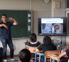
【Inquiry Study 1】Photogrammetry / Topography Deformation / Disaster Prevention Class (by Associate Professor Y. Hayakawa, Hokkaido University)
【Inquiry Study 2】Geology / Ground / Topography / Geology Class (by Associate Professor C. Oguchi, Saitama University )
【Inquiry Study 3】Architectural Cultural Properties (World Heritage) Class (by Associate Professor Masashi Morita, Yokohama National University)

【Inquiry Study 4】Cultural Heritages and Taya Cave class (by Associate Professor Keisuke Ogata, Tsurumi University)

【Inquiry Study 5】Typhoon No. 15/19 Damage Investigation Class (by Associate Professor Morita, Yokohama National University + Y. Tamura)
* Sakae Ward Comprehensive Study Time Workshop


